
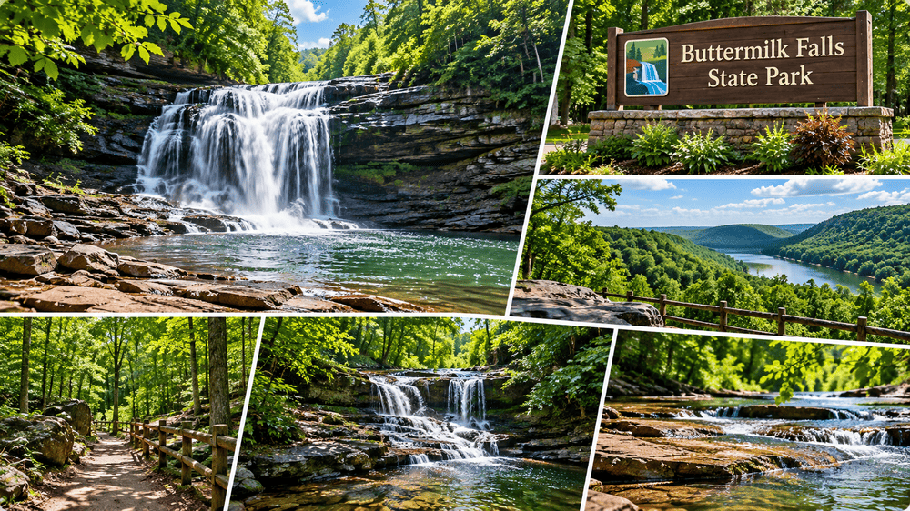
Buttermilk Falls State Park anchors the southern edge of Ithaca in Tompkins County, New York. The 811-acre reserve functions as a primary geographical feature of the Finger Lakes region, drawing high visitor volume through its deep ravines and exposed sedimentary rock formations. The physical layout of the property divides into two distinct operational zones: a steep, waterfall-heavy lower gorge and a flat, heavily wooded upper basin. The main cascade drops over 90 feet in a frothy, churning staircase pattern that historically gave the creek its name. Evaluating the glacial geology, the physical demands of the trail network, and the seasonal water cycles provides a clear framework for analyzing this prominent New York reserve.
Geological Formation And The Hanging Valley
The steep topography of the modern park traces its origins directly back to the last ice age. Massive continental glaciers advanced and retreated across central New York 20,000 to 30,000 years ago. The advancing ice sheet carved a deep, wide trough that eventually became the Cayuga Lake valley. Buttermilk Creek originally flowed at a much higher elevation. As the main glacier receded, it left the creek suspended high above the newly excavated valley floor, creating a geographical structure known as a hanging valley.
Gravity forces the creek water to drop 600 feet down the sheer rock face to reach the valley floor. This continuous water flow creates relentless mechanical erosion, slowly cutting backward into the hillside. The exposed rock walls display millions of years of sedimentary history, consisting entirely of Devonian shale and sandstone. The sedimentary layers represent ancient, shallow sea beds that covered the region hundreds of millions of years ago. Tectonic uplift eventually raised these sea beds high above the ocean level.

These specific rock types form in rigid horizontal layers. They fracture along straight, angular lines, creating the distinct, flat-topped staircases that define the waterfalls within the park. The modern winter climate accelerates the mechanical erosion process. Water seeps deep into the fractures of the Devonian shale during the day. Freezing overnight expands the ice, wedging the rock layers apart and causing heavy stone blocks to collapse into the plunge pools below.
The upper sections of the canyon feature complex water-carved structures. The relentless spinning of small stones caught in the current drilled deep, perfectly circular potholes directly into the creek bed. The most prominent geological anomaly in the upper gorge is Pinnacle Rock. This towering, freestanding stack of shale separated from the main cliff face centuries ago. Locals frequently compare this narrow, leaning spire to a natural tower, providing a stark visual contrast against the flat horizontal bedding of the surrounding canyon walls.
The Gorge Trail And Physical Demands
Human traffic moves through the canyon via a highly structured trail network. The Gorge Trail operates as the primary artery for park visitors. This 0.65-mile route traces the western edge of Buttermilk Creek, beginning right at the base of the main waterfall. The path forces hikers to ascend the entire 600-foot vertical drop in just over half a mile.
The physical demands of this ascent require sustained exertion. The trail relies heavily on heavy stone staircases and mortar bridges built by the Civilian Conservation Corps during the 1930s. The stonework executed by the Civilian Conservation Corps serves as a permanent physical record of the public works programs initiated during the Great Depression. The laborers sourced the stone directly from the surrounding hills, ensuring the artificial structures matched the color and texture of the natural canyon perfectly. The masonry blends directly into the natural shale, channeling foot traffic safely along the edges of the sheer drop-offs. The narrow width of the canyon blocks direct sunlight for most of the day, leaving the stone steps continuously slick from the ambient mist of the ten distinct waterfalls located along the route.

The constant moisture generated by the waterfall spray supports a highly specialized microclimate within the ravine. Dense patches of ferns and thick green moss cling directly to the vertical rock walls, thriving in the cool, shaded environment. The Rim Trail provides the standard return route, creating a 1.5-mile circuit. This 0.82-mile path runs along the opposite rim of the canyon, maintaining a much flatter grade high above the water. The dense tree canopy completely obscures the creek from this elevation, offering a quiet, shaded descent back to the lower parking lots.
Evaluating The Upper Park And Larch Meadow
The terrain levels out significantly upon reaching the upper park boundary. The creek slows down, winding through dense hardwood forests. The 0.67-mile Bear Trail picks up where the Gorge Trail ends, following the quiet upper waters in the direction of Lake Treman. The state created this small reservoir by damming the creek, providing a flat, still water body surrounded by a 1.5-mile loop trail. The upper park absorbs much less foot traffic than the main gorge, attracting hikers seeking long-distance routes. A short spur path connects Lake Treman directly to the Finger Lakes Trail, a massive overland route spanning hundreds of miles across New York.
The lower park features a distinct ecological zone separate from the rocky ravines. The Larch Meadow Trail Loop covers just over a mile of flat ground near the main camping office. This path crosses a wetland ecosystem sitting on the Cayuga valley floor. The saturated soil supports entirely different flora and fauna compared to the dry, shaded shale cliffs just a few hundred yards away. The flat terrain supports larger mammal populations. White-tailed deer frequently graze in the open fields surrounding the Larch Meadow, showing very little fear of human proximity. Avian life utilizes the dense hardwood canopy along the Bear Trail, with multiple species of woodpeckers and songbirds nesting in the mature oak and maple trees.
Historical Context And The Treman Donation
The modern public infrastructure of the park exists entirely through private philanthropy. In 1924, local philanthropists Robert and Laura Treman purchased the original 164 acres surrounding the main waterfall. They immediately transferred the deed to New York State, establishing the foundation of the current reserve. The state steadily acquired adjacent land parcels over the following decades, expanding the boundaries to the current 811-acre footprint. The name of the creek predates the park itself, originating from early 19th-century accounts describing the thick, white water resembling churning buttermilk.

Seasonal Operations And Swimming Infrastructure
The base of the main waterfall forms a massive, natural plunge pool. The state park administration converts this pool into an official swimming area during the summer months. Lifeguards monitor the deep water, creating a highly regulated, natural swimming hole right at the foot of the 90-foot drop. This aquatic infrastructure draws massive crowds from the nearby Cornell University campus and surrounding towns, frequently pushing the lower parking lots to absolute capacity on weekends.
The lower fields support a heavily utilized campground featuring both tent sites and modern cabins. Travelers structuring complex U.S. travel itineraries often utilize this specific campground as a logistical hub to explore the broader Finger Lakes region. The state closes the Gorge Trail completely during the winter months. Freezing temperatures turn the ambient waterfall mist into thick sheets of ice, rendering the narrow stone staircases entirely impassable. The Rim Trail remains open year-round, allowing visitors to observe the massive ice columns that form across the cliff faces. To verify current trail conditions, camping availability, and seasonal swimming hours, visitors must consult the live updates provided by the official New York State Parks administrative directory. The facility stands as a highly efficient recreational hub, balancing the raw geological history of the hanging valley with the heavy operational demands of a modern tourist destination.