

The Chihuahuan Desert hides a massive geological anomaly below its surface. Located in southeastern New Mexico, Carlsbad Caverns National Park operates as a primary study site for deep subterranean ecosystems. Congress established the site as a national park in 1930 to protect the intricate limestone chambers and the massive colonies of migratory bats living inside. The physical environment presents a sharp division between the harsh, sun-baked surface and the damp, pitch-black voids extending hundreds of feet underground. Evaluating the geological formations, the physical demands of the trail systems, and the seasonal bat migrations provides a clear structural blueprint of this natural phenomenon.
Geological Origins And The Permian Basin
The formation of this cave system differs completely from standard water-carved caverns. Most global cave networks form when slightly acidic rainwater slowly dissolves limestone near the surface. The Carlsbad system formed from the bottom up. The park sits on the edge of the Delaware Basin, a region holding massive deposits of petroleum and natural gas. Millions of years ago, hydrogen sulfide gas migrated upward from these deep oil reserves.
This gas eventually mixed with oxygen present in the underground water table. The chemical reaction produced sulfuric acid. This highly aggressive compound dissolved the surrounding limestone bedrock at an accelerated rate, carving out massive voids deep within the earth. As the Guadalupe Mountains experienced tectonic uplift, the water table dropped. The massive chambers drained, leaving behind empty spaces. Rainwater then began seeping down from the surface, carrying dissolved calcium carbonate. Dripping continuously over thousands of years, this mineral-rich water built the massive stalactites, stalagmites, and flowstones visible today. The sheer scale of these formations reflects the high concentration of minerals present in the desert rock above.
The Big Room And Structural Scale
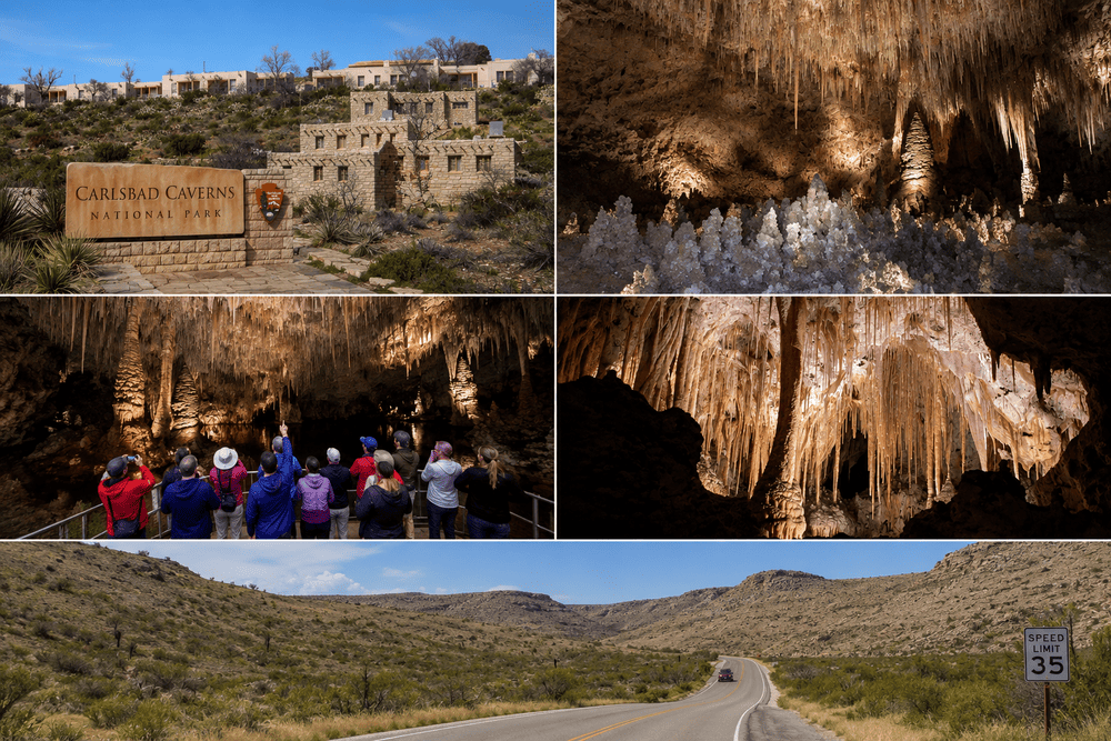
The primary destination for any visitor is the Big Room. This massive central chamber covers 8.2 acres, making it the largest single accessible cave chamber in North America. The scale disorients the human eye. The ceiling arches hundreds of feet overhead, disappearing into shadows beyond the reach of the installed lighting system.
The National Park Service maintains a 1.25-mile paved trail that loops around the perimeter of this cavern. Walking this circuit exposes visitors to highly concentrated clusters of geological formations. The Hall of Giants features towering stalagmites standing over sixty feet tall. The Bottomless Pit drops over one hundred feet into the floor, showcasing the extreme verticality of the original acid dissolution process.
The lighting infrastructure inside the chamber received massive upgrades in recent years. Engineers replaced outdated, high-heat incandescent bulbs with highly targeted LED systems. The older lights generated excess heat and encouraged unnatural algae growth on the delicate limestone surfaces. The new low-impact lighting preserves the visual drama of the formations and protects the long-term chemical stability of the rock.
Evaluating The Natural Entrance Descent
Visitors choose between two distinct methods for entering the deep cavern. The visitor center houses an elevator bank that drops 750 feet straight down in less than a minute. This mechanized route deposits guests directly at the start of the Big Room loop, bypassing the physical exertion of a major descent.
The Natural Entrance offers a highly physical, immersive alternative. This route begins at a massive opening on the surface and follows a steep, winding trail down into the earth. The path drops the equivalent of seventy-five stories over a 1.25-mile distance. The switchbacks cut through the twilight zone, the transition area where natural sunlight slowly fades into absolute darkness. Cave swallows nest in the upper reaches, flying in and out of the massive opening.
The physical toll of this hike is significant. The steep decline places heavy strain on the knees and ankles. The trail surface remains perpetually damp from the high internal humidity, requiring sturdy footwear with aggressive traction. The descent provides a clear visual record of the geological layers, letting hikers trace the exact path the sulfuric acid took as it carved out the limestone block.
| Descent Method | Distance | Elevation Change | Physical Demand |
| Elevator Access | Zero miles | 750 feet | Minimal |
| Natural Entrance | 1.25 miles | 750 feet | High |
Bat Flight Ecology And Conservation
The ecology of the cave relies heavily on a massive migratory mammal population. A colony of Brazilian free-tailed bats utilizes the caverns as a summer maternity roost. From late spring through early autumn, hundreds of thousands of these bats sleep attached to the ceiling of a restricted chamber near the Natural Entrance.
Their daily emergence remains one of the most documented biological events in the American Southwest. At dusk, the colony begins a massive upward spiral, exiting the cave in a dense, swirling cloud. The bats disperse across the Pecos River valley to hunt agricultural pests and desert insects. A single bat consumes its body weight in insects every single night. The sheer volume of this colony provides a massive natural pest control service for the surrounding agricultural districts.
The park administration manages this nightly event with strict operational rules. They constructed a concrete amphitheater facing the opening. Rangers enforce absolute silence during the flight. Electronic devices, including cell phones and cameras, must remain entirely shut off. The sudden flash of a screen or a camera strobe disorients the sonar navigation of the bats, causing them to crash into the stone walls. The official National Park Service portal outlines the exact daily schedule and behavioral requirements for these emergence events.
Surface Environment Of The Chihuahuan Desert
The underground chambers absorb the vast majority of visitor attention. The park boundaries encompass over 46,000 acres of remote, rugged Chihuahuan Desert on the surface. This above-ground environment features extreme climatic shifts. Summer daytime temperatures frequently push past 100 degrees Fahrenheit, dropping sharply after the sun sets over the Guadalupe Ridge.
The surface flora requires deep drought tolerance. Ocotillo, lechuguilla, and various agave species dominate the rocky slopes. The Walnut Canyon Desert Drive provides a continuous nine-mile gravel loop through this isolated terrain. The road exposes drivers to the raw, arid environment that sits directly above the damp cavern ceilings. Rattlesnakes, javelinas, and mule deer move through the scrub brush, surviving on minimal seasonal rainfall. The stark contrast between the dry, blinding surface and the wet, silent underground defines the complete biological profile of the park.
Visitor Logistics And Accessibility
Planning a visit requires managing location constraints and modern entry protocols. Carlsbad Caverns sits in a highly isolated section of the country. El Paso, Texas, operates as the nearest major transit hub, requiring a two-hour drive across open desert highways. Travelers organizing extensive U.S. travel itineraries frequently pair this destination with Guadalupe Mountains National Park, located just thirty minutes to the south.
The operational model for cave entry shifted permanently. The park administration instituted a mandatory timed-entry reservation system for all cavern access. Visitors must secure these digital reservations days or weeks in advance. Walk-up ticket sales rarely occur during the peak summer travel season.
The internal climate of the cave demands specific preparation. The temperature remains fixed at 56 degrees Fahrenheit year-round, regardless of the triple-digit heat on the surface. The humidity hovers near 90 percent. Packing a long-sleeved layer is a non-negotiable requirement for spending multiple hours exploring the deep trails. Navigating the logistics of tickets, geographic isolation, and physical preparation guarantees access to one of the most structurally complex geological sites on the continent.