

Analyzing Europe’s Premier Backcountry Destination
The northern frontier of Albania contains one of the most rugged and hydrogeologically complex limestone mountain ranges in southern Europe. Known formally as the Prokletije and colloquially as the Accursed Mountains, the Albanian Alps form a dramatic natural border shared with Montenegro and Kosovo. For decades, the extreme topography and a lack of paved infrastructure kept this region isolated from mainstream European tourism. Recent infrastructure investments have opened these high-altitude valleys to the global outdoor recreation sector. Evaluating the geological layout, primary trekking circuits, and local hospitality structures provides a practical blueprint for travelers analyzing this alpine territory.
Geological Characteristics And Environmental Layout
The Albanian Alps consist primarily of heavily karstified limestone and dolomite rock formations. This specific geology creates a highly dramatic, fractured terrain defined by sheer gray cliffs, deep glacial troughs, and extensive subterranean cave networks. Unlike the smoother, rounded profiles of central European ranges, the peaks here rise abruptly from the valley floors, with many summits exceeding 2,500 meters above sea level, such as Maja Jezercë.
The surface water behavior in this region depends heavily on the limestone composition. Rainwater and melting snow quickly sink into the porous rock, carving out underground channels before bursting forth as massive freshwater springs lower down the valleys. These springs feed high-volume rivers like the Valbona and the Shala, which feature remarkably clear, cold turquoise water. The northern microclimate brings heavy precipitation during the winter months, burying the high passes under deep snowpack that regularly lingers well into June, shaping the seasonal availability of the entire region.
The Valbona To Theth Trekking Circuit
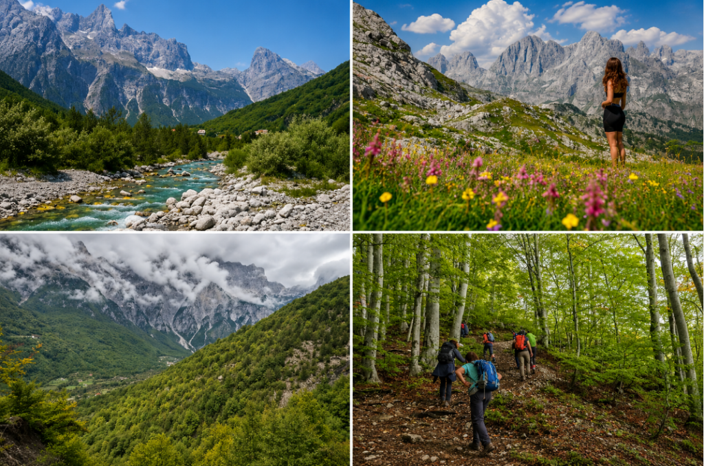
The central economic driver for adventure tourism in northern Albania is the mountain pass connecting the villages of Valbona and Theth. This single-day hiking route serves as a core segment of the broader Peaks of the Balkans trail network. The path spans approximately fifteen kilometers, requiring a sustained physical effort to overcome roughly one thousand meters of elevation gain and loss.
Hikers typically begin the trek in Valbona, moving upward through gravel riverbeds before ascending a steep, forested trail that gives way to exposed alpine meadows. The high point of the route, the Valbona Pass, sits at 1,759 meters and provides panoramic views of both glacier-carved valleys simultaneously. The descent into Theth is notoriously steep, dropping through beech forests and loose scree fields. Because this route functions as a point-to-point trail, logistics require careful planning regarding luggage transfers, which local operators handle using pack horses. For trekkers researching broader continental routes, our European travel guides offer comparative structural insights into how these Balkan paths compare to the crowded trail systems of Western Europe.
Structural Operations Of The Village Guesthouses
The hospitality infrastructure within the Albanian Alps relies almost exclusively on an authentic decentralized model known as the bujtina, or traditional guesthouse. This system developed organically as local families returned to the mountain valleys to convert their historic stone homes into functional tourist lodges. This approach stands in sharp contrast to the corporate resort developments found along the southern Albanian coastline.
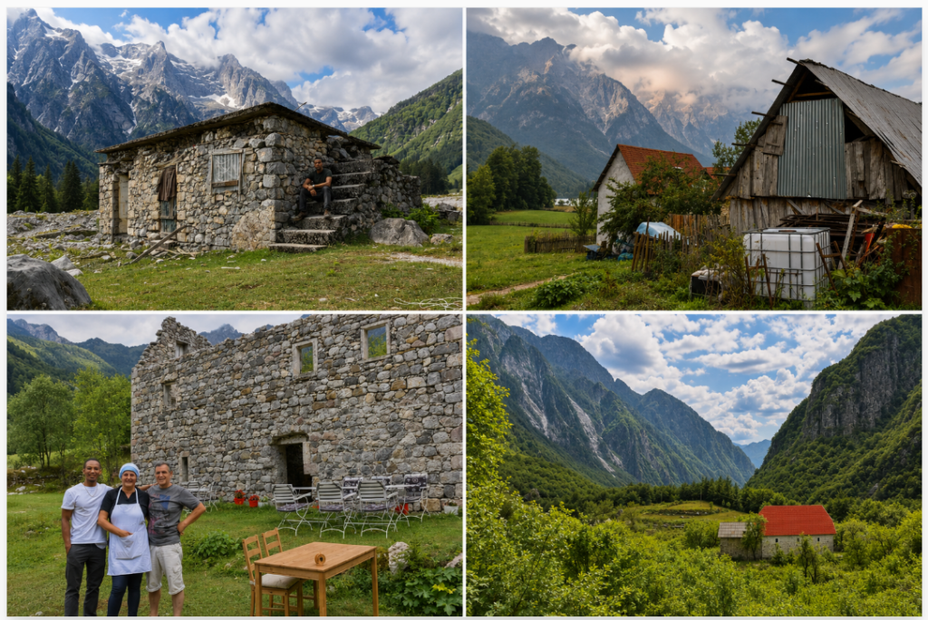
These guesthouses provide a structured, communal experience. Rates typically include overnight lodging in simple wood-paneled rooms along with hearty, fixed-menu breakfasts and dinners. The culinary program relies entirely on subsistence farming practices native to the Shkodër district. Guests eat homemade cheeses, slow-roasted mountain lamb, fresh trout, and organic vegetables grown directly on the property. The financial revenue generated by these guesthouses goes directly to the local families, providing a sustainable economic incentive to remain in the valleys during the harsh winter off-season and preventing the abandonment of historic alpine communities.
| Remote Hub | Primary Access Route | Signature Physical Landmark | Lodging Style |
| Theth | Paved road via Shkodër | Grunas Waterfall & Stone Lock-in Tower | Traditional stone bujtina |
| Valbona | Koman Ferry via Bajram Curri | Valbona River & Jezercë Massif | Wood cabins and converted homes |
| Vermosh | Northern highway via Tamarë | Kelmend Valley limestone canyons | Alpine farmsteads |
Transport Logistics And The Lake Koman Ferry
Reaching the trailheads of the Albanian Alps requires coordinating multiple modes of transportation, as the deep mountain valleys isolate the communities from direct transit routes. The northern hub city of Shkodër serves as the central staging ground for most expeditions. From Shkodër, travelers heading to Theth can utilize a fully paved mountain road that crosses the Buni i Thores pass, making the western valley accessible via standard passenger vehicles or shared minibuses called furgons.
Accessing the eastern valley of Valbona involves a more complex logistical sequence that incorporates the famous Lake Koman Ferry. This passenger and vehicular ferry runs through a narrow, reservoir-flooded canyon on the Drin River. The three-hour boat journey features sheer limestone walls rising hundreds of meters out of the green water, drawing frequent comparisons to Scandinavian fjords. For authoritative real-time scheduling, vehicle constraints, and pricing updates, travelers should consult the official Lake Koman Ferry portal before finalizing departure dates. The ferry drops passengers at the remote docks of Fierza, where domestic minibuses wait to transport hikers the remaining distance to Valbona.
Safety Protocols, Trail Markings, And Wildlife Dynamics
The wild, unmanaged state of the Accursed Mountains requires a higher degree of self-sufficiency than the highly manicured trail systems of Switzerland or Austria. While the main path between Valbona and Theth features consistent red-and-white painted trail markers, secondary routes into the high peaks can be poorly defined or obscured by rockslides. Cellular coverage drops out entirely inside the deep canyons, making downloaded GPS maps and physical topographic charts mandatory tools for safe travel.
The remote nature of the Alps preserves a highly intact ecosystem that supports large European carnivores. Dense beech and pine forests house stable populations of brown bears, Eurasian lynx, and grey wolves. While these animals avoid human contact along the heavily trafficked tourist paths, hikers entering isolated side valleys must manage food storage carefully to avoid attracting wildlife to backcountry campsites. Golden eagles and chamois occupy the higher rock ledges, utilizing the steep cliffs for protection against predators. By enforcing strict trail codes and discouraging unregulated wilderness dumping, local authorities aim to preserve this delicate ecological balance as visitor volumes scale up over the coming decade.